

The Department of Urban and Regional Planning, Faculty of Engineering, Diponegoro University, through the World Class University (WCU) Undip program, successfully conducted the Summer Course 2025. The theme of this program is GIS and Remote Sensing for Disaster Risk Based Spatial Planning in order to support resilient and sustainable urban planning (SDG 11 on sustainable cities and communities) through mitigation and adaptation to the impacts of climate change (SDG 13 on climate action). This Summer Course is an annual agenda of DURP Undip, which in 2025 was coordinated by the Geomatics and Planning Laboratory. The Summer Course 2025 served as a platform for collaboration between DPWK Undip and Chiba University (Japan) and the University of Hawai’i at Manoa (USA).
This Summer Course consists of both offline and online activities. The offline activities include lectures, workshops, field visits, and presentations, which were held from August 4–8, 2025. The online activities will be held from August 11–31, 2025, through MOOCs. The total number of Summer Course participants is 118 participants from 24 countries. Among the 10 international participants attending offline are representatives from Alexandria University (Egypt), Middle East Technical University (Turkey), Chiba University (Japan), Universiti Teknologi Malaysia (Malaysia), International Islamic University Malaysia (Malaysia), and Universiti Putra Malaysia (Malaysia). Additionally, there were 2 researchers from Germany affiliated with the Bintari Foundation and 17 undergraduate students from the Department of Urban and Regional Planning at the University of Diponegoro who participated in the program.
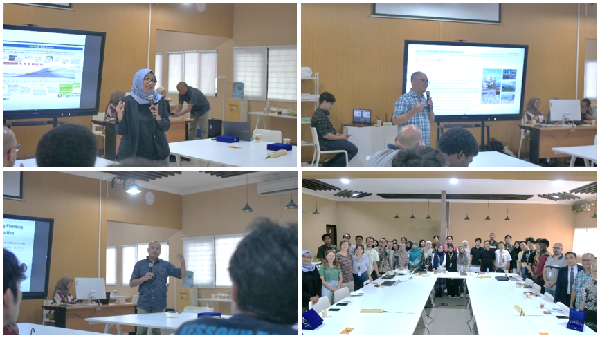
The Summer Course was officially opened by Prof. Dr. Ir. Hadiyanto, Director of Reputation, Partnership, and Global Connectivity of Undip, on Monday, August 4, 2025, at the DURP Undip Campus. The event continued with lectures by Prof. Dr.-Ing. Wiwandari Handayani (University of Diponegoro), Prof. Ashok Das (University of Hawai’i at Manoa, USA), and Prof. Dr.rer.nat. Imam Buchori (University of Diponegoro). The practical session was conducted and supervised by Assoc. Prof. Dr. Anang Wahyu Sejati (University of Diponegoro), Widjonarko, MT (University of Diponegoro), and Sri Rahayu, MSi (University of Diponegoro) on Tuesday, August 5, 2025, at the Spacelab DURP Undip.
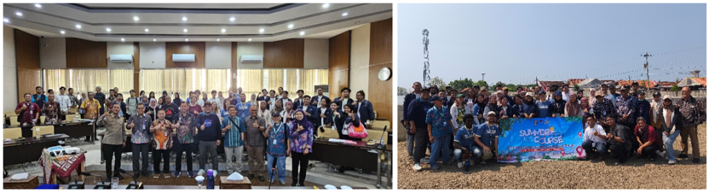
The field survey was conducted on Thursday, August 7, 2025, in Pekalongan City. The field survey activities began with a sharing session on flood disasters in Pekalongan City, presented by Mr. Cayekti Widigdo, AP., M.Si. (Head of the Regional Planning, Research, and Innovation Agency of Pekalongan City), Bambang Sugiarto, S.T., M.M. (Head of the Public Works and Spatial Planning Department of Pekalongan City), and Dimas Arga Yudha, S.Sos. (Head of the Prevention and Preparedness Section of the Regional Disaster Management Agency of Pekalongan City). The activities continued with a field visit to Pesona Housing Complex, Pekalongan Mangrove Park, and Cemoro Sewu Beach.

The chair of the Summer Course 2025 DURP Undip, Assoc. Prof. Dr. Anang Wahyu Sejati, explained that this program was designed to improve participants’ understanding of the role of spatial technology in supporting disaster risk reduction for resilient and sustainable spatial planning. In addition, it is hoped that this activity will produce a policy evaluation framework for the Pekalongan City Government in terms of coastal and disaster management.